Industrial Wales - Monmouthshire's Western Valley
Llanhilleth
From Swffryd to St Illtyds along the East bank
Search the site here
|
|
Industrial Wales - Monmouthshire's Western Valley
Llanhilleth
From Swffryd to St Illtyds along the East bank
|
Search the site here
|
 Hafodyrynys Road bridge |
 Heading towards Crumlin Viaduct |
 Heading towards Crumlin Viaduct |
 Heading towards Crumlin Viaduct |
 Heading towards Crumlin Viaduct |
 Heading towards Hafodyrynys |
 Crumlin Junction, Swffryd |
 Crumlin Junction |
 Crumlin Viaduct approach, Swffryd |
 Crumlin Viaduct abutment, Swffryd |
 The line to Royal Oak Junction |
 TVER Extension footbridge |
 TVER Extension footbridge |
 TVER Extension footbridge |
 The line to Royal Oak Junction |
 The line to Royal Oak Junction |
 The line to Royal Oak Junction |
 The line to Royal Oak Junction |
 The signal post near Swffryd |
 The signal post near Swffryd |
 The signal post near Swffryd |
 Retaining wall at Royal Oak Jct. |
 Royal Oak railway bridge |
 Royal Oak, c1925 |
 Swffryd Quarry (Monks) |
 Swffryd Quarry (Monks) |
 Swffryd Quarry (Monks) |
 Swffryd Quarry (Monks) |
 Swffryd Quarry (Monks) cave |
 Swffryd Colliery tramway bridge |
 Swffryd Colliery tramway bridge |
 Swffryd Ganol, 1920 |
 Swffryd Ganol Quarry |
 Swffryd Ganol quarry |
 Swffryd Ganol Farmhouse |
 Swffryd Ganol Farmhouse |
 Swffryd Ganol Farmhouse |
 Swffryd Ganol Farmhouse |
 Swffryd Ganol Farmhouse |
 Swffryd Ganol Colliery |
 Swffryd Ganol Colliery tips |
 Swffryd Ganol Colliery tips |
 Swffryd Colliery, 1962 |
 The oldest Swffryd level |
 The oldest Swffryd level |
 The oldest Swffryd level |
 The tramway to the Swffryd levels |
 The middle period Swffryd levels |
 The middle period Swffryd levels |
 The middle period Swffryd levels |
 The middle period Swffryd levels |
 Swffryd Colliery tip |
 Swffryd Colliery tip |
 Swffryd Colliery tip |
 Swffryd Colliery tip |
 Swffryd Colliery tip |
 Wagon frame in Swffryd Colliery tip |
 Swffryd Colliery tramway |
 Towards the main Swffryd levels |
 Swffryd Colliery South level |
 Swffryd Colliery North level |
 Swffryd Colliery North level |
 Llanhilleth Farm area, 1880 |
 Llanhilleth Farm area, 1901 |
 Llanhilleth Farm area, 1920 |
|
 Llanhilleth Farm Colliery |
 Llanhilleth Farm Colliery |
 Llanhilleth Farm Colliery |
 Llanhilleth Farm Colliery |
 Llanhilleth Farm Colliery |
 Farm Colliery incline |
||
 Farm Colliery incline |
 Farm Colliery incline |
 Farm Colliery incline |
 Farm Colliery incline |
 The site of The Rows |
 The Rows quarry incline |
 The Rows quarry incline |
 The Rows quarry |
 Farm Colliery incline |
 Cottage at lower end of incline |
 Llanhilleth Farm Colliery incline |
 Llanhilleth Farm Colliery incline |
 Llanhilleth Farm Colliery incline |
 Llanhilleth Farm Colliery incline |
 Llanhilleth Farm Colliery incline |
 Llanhilleth Farm Colliery incline |
 Llanhilleth Farm Colliery incline |
 Farm Colliery incline cottages |
 Farm Colliery incline cottages |
 Farm Colliery incline cottages |
 Ginny run or incline roller |
 Ginny run or incline roller |
 Ginny run or incline roller |
 Ginny run or incline roller |
 Barn to the North of the incline |
 Barn to the North of the incline |
 Barn to the North of the incline |
 Llanhilleth Farm Colliery tips |
 Llanhilleth Farm Colliery tips |
 Llanhilleth Farm Colliery tips |
 Llanhilleth Farm Colliery tips |
 Llanhilleth Farm Colliery tips |
Llanhilleth Farm, 1920 |
 Llanhilleth Farm 1920s level |
 Llanhilleth Farm Colliery |
 Llanhilleth Farm Colliery |
 Llanhilleth Farm Colliery rail |
 Old Llanhilleth Farm |
 Old Llanhilleth Farm |
 Old Llanhilleth Farm |
 Old Llanhilleth Farm |
 Old Llanhilleth Farm |
 Old Llanhilleth Farm |
 Old Llanhilleth Farm barn |
 Old Llanhilleth Farm barn |
 Cast-iron water pipe |
 Level behind old Llanhilleth Farm |
 Level behind old Llanhilleth Farm |
 Llanhilleth Farm level tips |
 Nant-y-cnyw Colliery, 1880 |
 Nant-y-cnyw Colliery, 1901 |
 Nant-y-cnyw Colliery, 1920 |
 Nant-y-cnyw Colliery, 1962 |
 Erskine Colliery ginny run building |
 Erskine Colliery main level |
 Erskine Colliery second level |
 Erskine Colliery tips |
 Erskine Colliery ginny run |
 Erskine Colliery ginny run |
||
 Nant-y Cnyw level |
 Nant-y-Cnyw level |
 Nant-y Cnyw level |
 Nant-y Cnyw level |
 Nant-y Cnyw level |
 Nant-y Cnyw level loading bank |
 Nant-y Cnyw level loading bank |
 LMS plate at Nant-y-Cnyw |
 Cwm Cyffin Quarry, 1901 |
 Cwm Cyffin Quarry incline |
 Cwm Cyffin Quarry incline top |
 Cwm Cyffin Quarry tramway |
 Cwm Cyffin Quarry tramway |
 Cwm Cyffin Quarry tramway |
 Cwm Cyffin Quarry tramway |
 Cwm Cyffin Quarry tramway |
 Small quarry next to tramway |
 Cwm Cyffin Quarry |
 Cwm Cyffin Quarry |
 Hafod Arthen Colliery, 1962 |
 Hafod Arthen Colliery ironmongery |
 Hafod Arthen Colliery ironmongery |
 Hafod Arthen Colliery tips |
 Hafod Arthen Colliery tips |
 Hafod Arthen Colliery tips |
 Hafod Arthen Colliery tips |
 Hafod Arthen Colliery tips |
 Hafod Arthen Colliery tips |
 Hafod Arthen Colliery tips |
 Hafod Arthen Colliery level |
 Hafod Arthen Colliery level |
 Hafod Arthen Colliery level |
 Hafod Arthen Colliery level |
 Hafod Arthen Colliery incline |
 Hafod Arthen Colliery incline |
 Hafod Arthen Colliery incline |
 Hafod Arthen Farm ruins |
 Hafod Arthen Farm ruins |
 Level beside Blaencyffin tramway |
 Level beside Blaencyffin tramway |
 Level beside Blaencyffin tramway |
 Foundations of first building |
 Foundations of first building |
 Foundations of first building |
|
 Foundations of second building |
 Foundations of second building |
 Foundations of second building |
 Foundations of second building |
 Blaencyffin tramway |
 Pipework on Blaencyffin tramway |
 Pipework on Blaencyffin tramway |
 Blaencyffin tramway stone sleeper |
 Blaencyffin tramway |
 Blaencyffin tramway |
 Blaencyffin tramway |
 Blaencyffin Uchaf Level |
 Blaencyffin Uchaf level |
 Blaencyffin Uchaf level |
 Blaencyffin Uchaf Level tramway |
 Blaencyffin Uchaf Level tips |
 Blaencyffin Uchaf Level tips |
 Blaencyffin Uchaf Level tips |
 Blaencyffin Uchaf Level tips |
 Blaencyffin Uchaf Level tips |
 Blaencyffin Uchaf Level tips |
 Blaencyffin Uchaf Level tips |
 Blaencyffin Colliery, 1899 |
 Blaencyffin Colliery, 1962 |
 Blaencyffin Colliery |
 Blaencyffin Colliery |
 Blaencyffin Colliery |
 Blaencyffin Colliery |
 Blaencyffin Colliery |
 Blaencyffin Colliery |
 Blaencyffin Colliery |
 Blaencyffin Colliery tips |
 Blaencyffin Colliery tips |
 Blaencyffin Colliery tips |
 Blaencyffin Colliery tips |
 Blaencyffin Colliery tips |
 Hafodyrynys Canyons |
 Blaencyffin Farmhouse |
 Blaencyffin Farmhouse |
 Blaencyffin Farmhouse |
 Blaencyffin Farmhouse |
 Penyrheol Colliery tips |
 Penyrheol Colliery tips |
 Penyrheol Colliery tips |
 Penyrheol level tramway |
 Penyrheol level |
 Penyrheol level incline |
 Penyrheol level tips |
 Penyrheol level tips |
 Penyrheol level tips |
 Penyrheol small level tips |
 Penyrheol small level tramway |
 Tramway to Mount Pleasant |
 Mount Pleasant Colliery site |
 Mount Pleasant Colliery tramway |
 St Illtyds Colliery tip canyon |
 St Illtyds Colliery tip canyon |
 St Illtyds Colliery tip canyon |
 St Illtyds Colliery tip canyon |
 St Illtyds Colliery tip canyon |
 St Illtyds Colliery tip |
 St Illtyds second level |
 St Illtyds trial level |
 St Illtyds level pylons |
 St Illtyds level pylons |
 St Illtyds level pylons |
 St Illtyds main level |
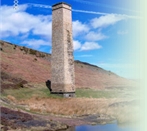
 Colliery entrance bridge pier |
 Llanhilleth Colliery 1880sy bridge |
 Aerial ropeway foundations |
 Aerial ropeway foundations |
 Llanhilleth Colliery memorial |
 Llanhilleth Colliery baths |
 Llanhilleth Colliery baths |
 Llanhilleth Colliery baths |
 Llanhilleth Colliery baths |
 Llanhilleth Colliery baths |
 Colliery baths, main road bridge |
 Llanhilleth Colliery baths steps |
 Waste tip bridge abutments |
 Waste tip bridge abutments |
 Hafod Arthen Isaf farm ruins |
 Hafod Arthen Isaf farm ruins |
Industrial WalesCollieries, Ironworks, Quarries, Railways, Canals, Tramroads, Tunnels, Culverts and so much more....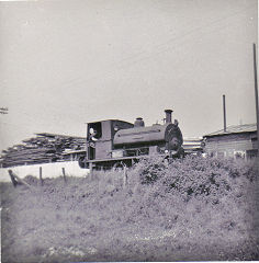
|
Brickworks of WalesBricks are 'History with a label' so here's the story of the Brickworks of Wales - photos, maps and the products themselves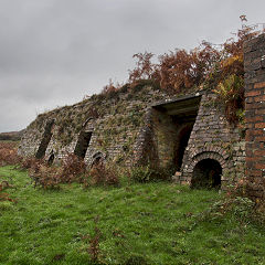
|
Around the WorldMy travels around the UK and the Whole Wide World in search of industries, railways, trams and mines to name a few.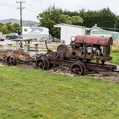
|
Boundary Stones and MilepostsBoundary Stones, Mileposts and other markers in simple alphabetical order of their initials, name or site.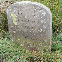
|
Ships and ShippingShips around the World in simple alphabetical order of their name (or apparent area if I can't read the name).
|
The Site Map and IndexA full list of all the pages of the whole website in just one place, so you should find exactly what you are looking for.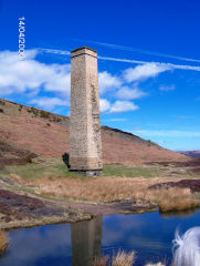
|
About the SiteThe background and technical details about the site, plus a contact page and links to other sites - and a warning !!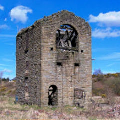
|
Contact MeSomething to add? A great photo? Something wrong? or need to know more about things? Just drop me a line here.
|
Further ReadingYou can find lots of local and other very helpful websites, books, magazines and Facebook groups all listed here.
|