Industrial Wales - Monmouthshire's Clydach Gorge
The Disgwylfa and Llangattock Tramroads
Bailey's tramroads to Disgwylfa and Llangattock Quarries
Search the site here
|
|
Industrial Wales - Monmouthshire's Clydach Gorge
The Disgwylfa and Llangattock Tramroads
Bailey's tramroads to Disgwylfa and Llangattock Quarries
|
Search the site here
|
 The Disgwylfa Tramroad, c1820 |
 The Disgwylfa Tramroad, c1820 |
 The Disgwylfa Tramroad, c1820 |
 Tramroad at Welfare Park |
 Tramroad at Park Crescent |
 Tramroad at Windsor Road |
 Tramroad at Windsor Road |
 Tramroad at Well Street |
 Tramroad at Well Street |
 Tramroad at Well Street |
 Tramroad crossing King Street |
 Tramroad along Clydach Street |
 Tramroad along Clydach Street |
 Tramroad along Clydach Street |
 Tramroad along Clydach Street |
 Tramroad along Clydach Street |
 Disgwylfa Tramroad garden |
 Disgwylfa Tramroad garden |
 Disgwylfa Tramroad garden |
 Tramroad along Clydach Street |
 Tramroad along Clydach Street |
 Tramroad along Clydach Street |
 Tramroad along Clydach Street |
 Tramroad to the Clydach bridge |
 Tramroad to the Clydach bridge |
 Beyond Clydach Street, Brynmawr |
 Tramroad to the Clydach bridge |
 Tramroad to the Clydach bridge |
 Tramroad to the Clydach bridge |
 Tramroad to the Clydach bridge |
 Tramroad to the Clydach bridge |
 Tramroad to the Clydach bridge |
 Tramroad to the Clydach bridge |
 Tramroad to the Clydach bridge |
 Tramroad to the Clydach bridge |
 Tramroad to the Clydach bridge |
 The site of the Clydach bridge |
 The Tramroad from Clydach Dingle |
 Crossing Nant-yr-Hafod |
 Crossing Nant-yr-Hafod |
 Crossing Nant-yr-Hafod |
 Crossing Nant-yr-Hafod |
 Looking back from Nant-yr-Hafod |
 Baileys Disgwylfa Tramroad |
 Baileys Disgwylfa Tramroad |
 Baileys Disgwylfa Tramroad |
 Baileys Disgwylfa Tramroad |
 Baileys Disgwylfa Tramroad |
 Baileys Disgwylfa Tramroad |
 Baileys Disgwylfa Tramroad |
 Baileys Disgwylfa Tramroad |
 Baileys Disgwlfa Tramroad |
 Baileys Disgwylfa Tramroad |
 Baileys Disgwylfa Tramroad |
 Baileys Disgwylfa Tramroad |
 Disgwylfa Quarries |
 Disgwylfa Quarries |
 Disgwylfa Quarries |
 Disgwylfa Quarries |
 Disgwylfa Quarries |
 Disgwylfa Quarries |
 Disgwylfa Quarries |
 Disgwylfa Quarries |
 Disgwylfa Quarries |
 Disgwylfa Quarries |
 Disgwylfa Quarries |
 Disgwylfa Quarries |
 Disgwylfa Quarries |
 Disgwylfa Quarries |
 Disgwylfa Tramroad West |
 Disgwylfa Tramroad West |
 Disgwylfa Quarries |
 Ty'r-ywen barn, Disgwylfa |
 Coed Cae Mawr dram |
 Coed Cae Mawr dram |
 Coed Cae Mawr flat wagon |
 Coed Cae Mawr haulage engine |
 Coed Cae Mawr haulage engine |
 Coed Cae Mawr haulage engine |
 Coed Cae Mawr haulage engine |
 Coed Cae Mawr haulage shed |
 Coed Cae Mawr screens |
 Coed Cae Mawr screens |
 Coed Cae Mawr screens |
 Coed Cae Mawr tippler |
 Coed Cae Mawr tippler |
 Coed Cae Mawr tramway |
 Coed Cae Mawr |
 Coed Cae Mawr |
 Coed Cae Mawr |
 Coed Cae Mawr |
 Cwm Nantmelin upper level |
 Cwm Nantmelin lower level |
 Cwm Nantmelin aqueduct |
 Cwm Nantmelin aqueduct |
 Cwm Nantmelin tips |
 Pant-Mawr Quarry |
 Pant-Mawr Quarry and Ty-yn-y-coed |
 Ty-yn-y-coed embankment |
 Coed Pantydarren Quarry |
 Coed Pantydarren Quarry |
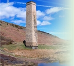
 Tramroad monument, 2006 |
 Craig-y-Gaer Quarry |
 Craig-y-Gaer Quarry |
 Craig-y-Gaer Quarry |
 Craig-y-Gaer Quarry limekiln |
 Craig-y-Gaer Quarry |
 Craig-y-Gaer Quarry |
 Craig-y-Gaer Quarry |
 Craig-y-gaer sewage tank |
 Craig-y-gaer sewage tank |
 Craig-y-gaer sewage tank |
 Craig-y-gaer sewage tank |
 Craig-y-gaer sewage tank |
 Craig-y-gaer sewage tank |
 Coedcae Uchaf, 1880 |
 'Cymro', Coedcae Uchaf |
|
 Coedcae Uchaf Limekiln |
 Coedcae Uchaf Limekiln |
 Coedcae Uchaf Limekiln |
 Pant-y-rhiw, Llangattock, 1880 |
 Waun Watcyn Tramroad |
 Waun Watcyn Tramroad |
 Waun Watcyn Tramroad |
 Waun Watcyn Tramroad |
 Waun Watcyn Tramroad |
 Waun Watcyn Tramroad |
 Waun Watcyn Tramroad |
 Waun Watcyn Tramroad |
 Waun Watcyn Tramroad |
 Waun Watcyn Tramroad |
 Pant-y-rhiw Limekiln |
 Pant-y-rhiw Limekiln |
 Pant-y-rhiw Limekiln |
 Pant-y-rhiw Limekiln |
 Pant-y-rhiw Limekiln |
 Pant-y-rhiw Limekiln |
 Pant-y-rhiw Limekiln |
 Pant-y-rhiw Limekiln |
 Pant-y-rhiw Limekiln |
 Pant-y-rhiw Limekiln |
 Daren Quarry |
 Daren Quarry |
 Pant-y-rhiw Incline |
 Pant-y-rhiw Incline |
 Pant-y-rhiw water tank |
 Pant-y-rhiw Quarry |
 Pant-y-rhiw Quarry |
 Pant-y-rhiw Quarry |
 Pant-y-rhiw Quarry |
 Pant-y-rhiw tramplate and sill |
 Pant-y-rhiw tramplate and sill |
 Tramroad embankment |
 Waun Watcyn Quarry |
 Tramroad at Pant-y-rhiw |
 Tramroad at Pant-y-rhiw |
 Tramroad at Pant-y-rhiw |
 Quarry near the incline head |
 Quarry tips near the incline head |
 Tramroad near the incline head |
 Tramroad sleepers near the incline |
 Tramroad sleepers near the incline |
 Upper incline brakehouse |
 Upper incline from brakehouse |
 Chwar Mawr Tramroad, 1880 |
 Chwar Mawr Tramroad |
 Chwar Mawr Tramroad |
 Chwar Mawr Tramroad |
 Chwar Mawr Tramroad |
 Chwar Mawr Tramroad |
 Chwar Mawr Tramroad |
 Chwar Mawr Tramroad |
 Chwar Mawr Tramroad |
 Chwar Mawr Tramroad |
 Chwar Mawr Tramroad Terminus |
 Chwar Mawr Tramroad Terminus |
 Chwar Mawr Tramroad sleeper |
 Chwar Mawr 'stone chute' |
 Chwar Mawr 'stone chute' |
 Chwar Mawr 'stone chute' |
 Chwar Mawr Tramroad building |
 Llangattock Inclines, 1880 |
 Llangattock Wharf, 1880 |
|
|
Upper incline brakehouse |
Upper incline from brakehouse |
 Upper incline looking down |
 Lower incline looking up |
 Tramroad to Llangattock wharf |
 Tramroad towards inclines |
 The tramroad bath house |
 Llangattock Tramroad sleepers |
 Llangattock wharf and limekilns |
Industrial WalesCollieries, Ironworks, Quarries, Railways, Canals, Tramroads, Tunnels, Culverts and so much more....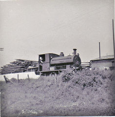
|
Brickworks of WalesBricks are 'History with a label' so here's the story of the Brickworks of Wales - photos, maps and the products themselves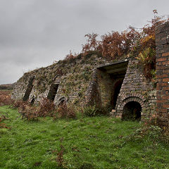
|
Around the WorldMy travels around the UK and the Whole Wide World in search of industries, railways, trams and mines to name a few.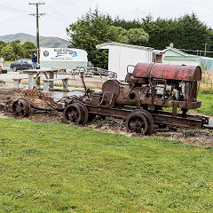
|
Iron and StoneBoundary Stones, Mileposts and any kind of ironmongery from drain covers to builders plates.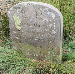
|
Ships and ShippingShips around the World in simple alphabetical order of their name (or apparent area if I can't read the name).
|
The Site Map and IndexA full list of all the pages of the whole website in just one place, so you should find exactly what you are looking for.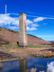
|
About the SiteThe background and technical details about the site, plus a contact page and links to other sites - and a warning !!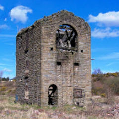
|
Contact MeSomething to add? A great photo? Something wrong? or need to know more about things? Just drop me a line here.
|
Further ReadingYou can find lots of local and other very helpful websites, books, magazines and Facebook groups all listed here.
|